
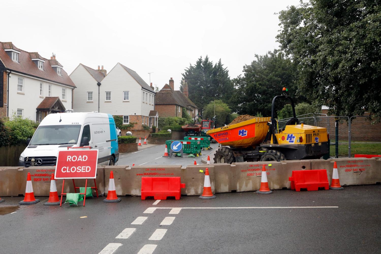
Key facts
Location: Battle Road, Cade Street, Middle Lane, School Hill, Old Heathfield Road and additional side roads
Work: Replaced approx. 6.5 kilometres of water main
Started: Tuesday 7 May 2024
Completed: Tuesday 9 September 2025
Investment: £5.6 million
We’ve invested £5.6 million in upgrading the water network in between Heathfield and Rushlake Green, East Sussex, to improve the quality of your drinking water.
The water supply in the area was not the standard we want for our customers and discolouration was a common issue. To help improve this, we replaced approximately 6.5 kilometres of old water main along Battle Road, between Heathfield and Rushlake Green.
Project details
Work started on Tuesday 7 May 2024, and we completed work in September 2025
We worked under a mixture of temporary traffic lights and rolling road closures of around 150 metre sections to ensure residents and businesses could still access their property, and to minimise disruption for through traffic.
Where road closures were required, these were phased to avoid multiple roads being closed at the same time and we worked with the local authority to agree diversion routes.
Closures around the school were arranged for the school holidays to avoid disturbance during exam season.
We would like to thank the community for their patience while we carried out this vital work.


This work is part of a wider plan to improve the water supply network in East Sussex, with work also taking place in Rother, at our Bewl Water Treatment Works and in the Wadhurst area.
Project updates
Tuesday, 9 September 2025
09:55 AM
Project completed
We're pleased to say all road closures and temporary traffic lights were removed and the roads fully reopened on Tuesday 2 September, ahead of schools returning after the summer break.
Once we've finished clearing away our compound area, this project will be finished. We'd like to thank the community for their patience while we carried out this vital work to improve water quality in the area.
Monday, 11 August 2025
10:14 AM
We're now entering the very final stages of this project with the last sections of pipe now laid in Cade Street and Battle Road.
Pipeline testing has also completed and this week we'll connect the final few properties in Battle Road, Cade Street, Old Heathfield Road and School Hill up to the new water main. We also have some final main connections to undertake this week.
We hope that by the end of the week we'll have begun permanently reinstating these roads before sealing off the old pipes enabling us to complete the project.
Monday, 4 August 2025
07:22 AM
Last week the 200 metres of new water main was laid as planned in Battle Road. This week we'll be testing that new pipeline and preparing to connect the properties alongside up to it. Some properties may experience a short interruption to their water supply during 7 August as we connect the new pipeline up to the existing network. If you're going to be affected, our team will let you know beforehand.
Along Old Heathfield Road and School Hill to Cade Street we've also installed 200 metres of new pipeline. This week we'll test that new pipeline and begin preparations to connect nearby properties up to it. We'll also lay the final section of new water pipe at junction with School Hill.
Monday, 28 July 2025
13:28 PM
Last week, we set up road closures on Middle Lane, Battle Road and Old Heathfield Road. We've also put two-way temporary traffic lights on Cade Street.
In Battle Road, we've excavated the required spaces to allow us to identify the location of existing utilities, and to prepare for laying a new section of main using the directional drilling method. This week, we'll be installing 200 metres of new water main in this working area, and preparing to connect customer supplies to the new main.
In Old Heathfield Road, we've laid 200 metres of new pipeline, and this week, we'll be digging out further pits to lay the next 200 metre section using the directional drilling method.
Monday, 21 July 2025
08:38 AM
Returning to complete our project
We're returning to finish our work to install around 6.5 kilometres of new water main between Heathfield and Rushlake Green.
This week, we'll be closing the following roads for around six weeks:
- Middle Lane, at the junction with Battle Road (closing the right turn fork only for the first few days, then the junction will be fully closed)
- B2096 (Battle Road), from the junction with Blackdown Lane to Three Cups Corner at the junction with Middle Lane
- Old Heathfield Road, between the junctions with School Hill and Cade Street. There will also be temporary traffic lights on Cade Street for the duration of this work.
Tuesday, 22 April 2025
12:46 PM
A short pause
We've now removed all traffic management from Battle Road and will shortly be leaving the area completely. The remaining sections - Old Heathfield Road and Three Cups Corner - will be completed under a full road closure during the summer holidays to minimise disruption.
We'll be returning in July to complete this work.
Friday, 4 April 2025
14:48 PM
In our working area on Battle Road east of the junction with Blackdown Lane, we've connected the new pipeline to the existing network and prepared to make connections to customer supply pipes. We've started filling in the excavations ready to return the working area to its original condition. This will be completed over the next two weeks, once we've finished transferring all customers to the new main.
The equipment installation has now been completed on Cade Street, at the junction with Hugletts Lane.
Tuesday, 1 April 2025
12:34 PM
Last week, we returned our working area at the Battle Road/Cade Street junction with School Hill to its original condition and removed all traffic lights and traffic management from this area. For the next few weeks, we'll be returning the footpath to a safe and useable condition and disconnecting and sealing off the old mains before leaving this section for a few weeks. We'll be returning to Old Heathfield Road on 23 July, working under a full road closure during the school summer holidays.
On Thursday 3 April, we will need to have two-way traffic lights in place for one day at the junction of Hugletts Lane while we carry out a piece of work on equipment at that location.
Further along Battle Road, we're continuing to work east from Blackdown Lane towards Three Cups Corner. Last week, we laid a further 200 metres of new pipeline and prepared to transfer customer supply pipes to this new section. This week, we'll be joining this new section to the existing network and preparing and testing it ahead of bringing it into service. We're expecting to be working on this section until Saturday 19 April and will then leave for a few weeks before returning on 23 July to complete the final section under a full road closure in the summer.
Monday, 24 March 2025
11:17 AM
In our working area at the junction of Battle Road and School Hill, we've now connected the new main to the existing network and have returned part of the working area to its original state so we can change the temporary traffic management from three-way lights to two-way lights. This week, we'll be continuing this so that we can completely remove the temporary traffic lights.
Further east along Battle Road, we've installed another 100 metres of pipeline as we continue to work east from the junction with Blackdown Lane towards Three Cups Corner. This week, we'll be testing the new main and making sure it's ready to service, and while we wait for the results, we'll be preparing to connect several customer supply pipes.
By around mid-April, we'll be leaving the area and all traffic lights will be removed. We will need to return on 23 July, during the school summer holidays to complete work in Old Heathfield Road and Three Cups Corner under road closures. We will send a reminder of this nearer the time.
Monday, 17 March 2025
17:12 PM
We're currently waiting for the testing and sampling results from the final section of water main laid along Battle Road between the A265 and School Hill. Once these have been received, we'll be connecting the new main to the existing network before returning the working area to its original condition. Traffic lights will then be changed from three-way lights to two-way lights.
Further east along Battle Road, last week we laid a further 200 metres of new water main, and are preparing to lay another 200 metres this week as we work away from Blackdown Lane, heading towards Three Cups Corner. Once we reach the section where the road narrows, we'll be leaving site completely before returning in July to complete the remaining work in Three Cups Corner under a full road closure.
Monday, 10 March 2025
09:43 AM
We've completed laying the new main along Battle Road from the A265 to School Hill, and now need to complete testing of this. We'll then make the new main ready to take water before bringing it into service. We need to make a connection to the existing network, and transfer several customer supply pipes to the new main.
At the Blackdown Lane end of Battle Road, we've transferred customer services to the new main, and have returned the road back to its original state and reopened Blackdown Lane. Traffic management has been moved east along Battle Road ready for us to lay the next 200 meters of pipeline.
Monday, 3 March 2025
15:28 PM
We're continuing to work along Battle Road and are currently at the junction with School Hill. The the final section of pipe for this stage will be laid this week, and a connection made to our existing network. Once this has been completed and the main successfully tested, we'll be returning the working area to its original condition and start transferring customer supplies along Battle Road. We'll also be returning the grass verge by the A265 back to its original condition.
Further down Battle Road, we're working east from Blackdown Lane towards Three Cups Corner. This week, we'll be transferring the remaining customer supply pipes to the new main on Battle Road before moving the traffic lights along the road so we can lay the next 200 metre section. Once we reach the point where the road narrows, we'll be leaving the area before returning during the school summer holidays to work at Three Cups Corner.
Monday, 24 February 2025
09:16 AM
We've now laid around 620 metres of new pipeline from the junction with the A265 along Battle Road. The traffic lights have now moved to the junction with School Hill and these are now three-way lights as we work at the junction this week.
At the opposite end of Battle Road, we've installed 100 metres from the junction with Blackdown Lane, and this is currently being tested. This week, once we've received successful results, we'll be connecting customer supply pipes to the new main. We'll then return the working area to its original state and move the traffic lights along to the next 100 metre section.
Monday, 17 February 2025
09:00 AM
We've laid a further 100 metres of new main along Battle Road, working east away from the junction of the A265 towards School Hill, taking our total for this section to 520 metres. This week, we'll be laying the next 100 metre section. Once that is laid, we'll return the working area to its original state and move the traffic lights along to the next section. The lights will be changed from two-way lights to three-way lights, to include the junction with School Hill.
This week we'll also be laying 100 metres of new water main along Battle Road, east from the junction with Blackdown Lane.
Monday, 10 February 2025
09:21 AM
We're continuing to work east along Battle Road away from the junction with the A265, with another 200 metres of new pipeline laid this week. This week we'll be moving the traffic management to the next section as we carry on working along the road, towards School Hill.
We've also resumed work further along Battle Road, with two-way traffic lights at the junction with Blackdown Lane. There is further traffic management to control flow of traffic into and out of Blackdown Lane. We'll be working east, and will be excavating and laying 100 metres this week.
Monday, 3 February 2025
13:14 PM
We've laid a further 200 metres of new water main along Battle Road working east from the junction with the A265. We've returned the working area to its original state and this week, we'll be moving the traffic lights along the road to prepare for the next section of drilling to lay more pipeline.
We've completed our section of work in Cade Street, opposite Hugletts Lane, and this week, the team who were working here will be moving further along Battle Road. Traffic lights will be set up at the junction with Blackdown Lane and we'll be working east.
Monday, 27 January 2025
17:07 PM
Last week, we prepared and installed 200 metres of new pipeline from the A265 along Battle Road. This week, we’ll make the road safe to use again before moving our working area along Battle Road in preparation for laying the next 200 metres.
In Cade Street, opposite Hugletts Lane, we’ve completed the required pipe and ground work for the new booster to be installed. This week, we’ll be returning the working area to its original state and will be checking to make sure all customer services in this area are connected on to the new water main.
Tuesday, 21 January 2025
17:07 PM
Last week, we dug out a section of the verge of the A265 and Battle Road to lay additional pipework and equipment to support and monitor the network. We have returned our working area on the A265 and part of the footway to their original state, to allow for the traffic lights to be moved the next working area. We will be working in verge and will need to revisit this section at a future date to connect the new pipework to our network. The verge will be fenced off during this time and we'll return it to its original state once we've completed our work.
This week, we’ll be continuing to work between the A265 and Battle Road, and will be preparing to lay a section of pipework into Battle Road using the directional drilling method.
Opposite Hugletts Lane in Cade Street, we continue to install the required pipework ready for a new booster to be installed.
Monday, 13 January 2025
09:07 AM
Our teams returned to work after the Christmas break on Monday 6 January, setting up a road closure on Hugletts Lane and two-way traffic lights at the junction of Battle Road and the A265.
We’re pleased to say that work in Hugletts Lane was completed early and the road has now reopened. We’d like to thank the residents for their patience and Heathfield Chapel for supporting the works by allowing residents to park in the lay-by outside the chapel. This week, we’ll be working in the verge on Cade Street, opposite the junction for Hugletts Lane to install the required pipework for a new booster.
At the junction of Battle Road with the A265, we’re continuing to excavate this week which will allow us to make a connection to our existing network. Once this is completed, we’ll start moving our working area along Battle Road away from the junction and towards School Hill.
Tuesday, 17 December 2024
10:53 AM
Break in work over Christmas
In our working area on Battle Road, between the junctions with Bakery Lane and Blackdown Lane, we’ve transferred a further five customer supply pipes to the new main, and we’re awaiting test results for the next 100 metres of new pipeline before we connect the remaining supply pipes. Once they have been completed, we’ll be returning the road to its original state, ready to clear away the traffic lights on Friday, 20 December. After the Christmas break, the team working on this section will be moved to work on the junction of the A265 Burwash Rd and Battle Road.
In Cade Street, we’ve been preparing for the work required at the junction with Hugletts Lane, which will be carried out in the new year. This week, we’ll also be preparing to clear away the traffic lights from the road ahead of the Christmas break.
Friday, 29 November 2024
16:30 PM
This week, we made a connection to our existing network and transferred 16 customer supply pipes to the new water main. We returned our current working area on Battle Road between North Street and Blackdown Lane to its original state. Next week, we’ll be preparing to lay the next 200 metre length of new pipeline. To do this, we’ll excavate several pits to allow us to use the directional drilling method.
In Cade Street, we’ve now laid a total of 670 metres and next week, we’ll be transferring several customer supply pipes to the new main, connecting to the existing network and returning part of the working area to its original state as we move along towards Hugletts Lane.
Friday, 22 November 2024
15:46 PM
This week, we installed a further 100 metres along Battle Road working east from the junction of North Street towards the junction with Blackdown Lane. The new length of main has been tested and made ready to use. We are just waiting for successful sampling, and then we’ll transfer customer supply pipes to this new section next week. Once we’ve completed that, we’ll make the road useable again and move along to the next section.
Work is also progressing well along Cade Street, with the rest of the new main in this section set to be laid next week. We’ll then need to make sure all customer supply pipes have been connected, along with connections to the existing network.
In total, we’ve now installed 4.7 kilometres of new water main. We're currently planning on removing all traffic management for Christmas to completely reopen the road from Friday 20 December to Thursday 2 January.
Monday, 11 November 2024
15:34 PM
Work was completed across the junction of Battle Road and Bakery Lane, with Bakery Lane reopened on Friday as planned. This week, we’ll be installing the next 200 metres of new pipeline using the directional drilling method, which means you’ll see several small pits excavated along the road rather than one long open trench.
The working area on Cade Street has moved east towards Hugletts Lane, where we’ll preparing and installing 136 metres of new water main, also using the directional drilling method.
Tuesday, 5 November 2024
10:09 AM
On Battle Road, we’ve now started to cross Bakery Lane with our new pipeline. We’ll be installing this smaller section of main, making connections and transferring services to allow us to reopen the junction on Friday 8 November.
In Cade Street, we’ve installed a further 134 metres of new pipeline. This week, we’re transferring customer supply pipes before we return the current working area to its original condition and moving along to the next working area. This will be east of the garden centre and working toward Hugletts Lane
Wednesday, 30 October 2024
09:46 AM
Last week we received successful testing results and were able to connect customer supply pipes to the newest section of water main between Flitterbrook Lane and Bakery Lane. Once this was completed, we restored the road to its original condition and this will continue this week as we prepare to work across the junction of Battle Road and Bakery Lane. This will begin on 4 November.
In Cade Street, we had to carefully excavate the required pits to allow us to drill the next section of pipework to ensure we remain a suitable distance from existing utilities. This 134 metre section of pipeline was successfully installed earlier this week. While we await test and sampling results this week, we’ll be preparing to connect customer supply pipes to the new main.
Friday, 18 October 2024
07:57 AM
This week, we installed just over 100 metres of new pipeline on Battle Road between the junctions with Flitterbrook Lane and Bakery Lane. This is now undergoing testing and sampling ahead of being brought into service. While we await the test results, we’re preparing to connect customer supply pipes to the new main. These connections will take place next week, once we’ve received successful test results, and we’ll then restore the current working area to its original state.
In Cade Street, we’ve started returning the current area to its original state. We have the last few customer supply connections to finish on this section and these will be completed next week. We're planning to prepare and install the next 150 metre section of new pipeline using the directional drilling method.
Please note that from Monday 4 November, we will need to close Bakery Lane at its junction with Battle Road for five days to allow us to cross this section with the new pipework.
Friday, 11 October 2024
15:06 PM
This week we’ve transferred a further 19 customer supply pipes to the new water main in Battle Road and are now restoring the current working area to its original state ready to move along to the next section.
In Cade Street, we’ve now laid a total of 400 metres of new pipeline. Next week, we’ll be preparing to transfer customer supply pipes while we wait for testing results to return. Once we have successful results, we’ll make the connections and restore the current working area to its original condition.
Tuesday, 8 October 2024
15:51 PM
We were able to reopen Flitterbrook Lane on Monday, now that we have completed this section of work. We are currently working to transfer 23 customer supply pipes to connect to the new section of main, which we will be doing throughout this week, before moving the traffic management further along Battle Road towards Bakery Lane.
In Cade Street, we’ll be transferring the final three services on our current section then restoring the current working area to its original state before preparing to drill the next section of new main.
Monday, 30 September 2024
15:32 PM
Across this project, we’ve now laid over four kilometres of new water main. A total of 1347 metres of new pipeline has been installed along Battle Road, with 84 houses now connected to this new main. We’ll continue transferring customer supply pipes to the new main this week, once testing and sampling have returned successful results. Once this is completed, we’ll restore the current working area and move along Battle Road to the next section.
In Cade Street, we’ve laid a total of 300 metres and transferred nine houses to the new main. As with Battle Road, we’ll be connecting more customer supply pipes this week once the new main has passed the necessary testing. This week, we’ll also be preparing for the next section of main to be laid using the drilling method.
We’re pleased to say we are currently working ahead of schedule and are reviewing the programme for the remainder of the project. Updates will be provided once any changes are confirmed.
Monday, 23 September 2024
08:43 AM
Battle Road
This week, we’ll be laying 200 metres of new water main on Battle Road, working across the junction with Flitterbrook Lane, which remains closed. We’ll be preparing to transfer customer supply pipes to the new main once it has been successfully tested.
Cade Street
Last week we moved the working area along to the next section and made the necessary preparations to allow us to lay a further 150 metres of new water main this week using the directional drilling method. We’ll be preparing to transfer customer supply pipes to the new main once it has been successfully tested.
Monday, 16 September 2024
08:47 AM
Battle Road
Traffic lights have now been moved to the junction with Flitterbrook Road, and this road is now closed until Thursday 3 October. This week, we’ll be preparing the working area to lay 100 metres of pipeline using the directional drilling method, with the aim of installing this by the end of the week. Barley Mow Lane has been reopened.
Cade Street
Last week, we installed 150 metres of new pipework along Cade Street using the directional drilling method. Once testing and sampling is complete, we’ll transfer customer supply pipes to the new main. This week, we’ll return the current working area to its original state before moving along to the next 150 metre section.
Monday, 9 September 2024
10:48 AM
We’re continuing to move along Battle Road working east of Coldharbour Lane, and are also currently working in Barley Mow Lane. In Cade Street, we’ve excavated the required pits ready to install 150 metres of water main this week using the directional drilling method.
Monday, 2 September 2024
13:35 PM
Battle Road
A total 1,147 metres has now been laid along Battle Road, and this week, we started on Barley Mow Lane with just under 60 metres of water main being replaced. This week, once we’ve received successful results from sampling, testing and chlorinating the new pipework, we’ll transfer six customer services and return the working area to its original condition.
School Hill
We’ve now completed work on School Hill and the road has been reopened in time for the end of the summer holidays.
Cade Street
Work will be starting between Cade Street and Hugletts Lane this week, with two-way traffic lights set up. We’ll be preparing to drill the next section of water main by excavating the necessary pits.
Monday, 12 August 2024
10:15 AM
Battle Road
We’ve now laid a total of 887 metres of new water main within Battle Road. We’ve transferred seven more customer services to the new section of main and returned the current working area back to its original state. The temporary traffic lights have been moved along the road to the next section, where we have been carrying out preparatory work to install the next length of water main using directional drilling methods. This week, we’ll install the next 100 metres along Battle Road using this technique and prepare to transfer 27 customer services.
Halley Road
We’re pleased to say all works have been completed in Halley Road, and it has been reopened.
School Hill
Preparations have been completed between School Hill’s junctions with Portland Square and Old Heathfield Road so that the next section of pipe installation can be undertaken this week by directional drilling methods. We’ve prepared customer services so that these are ready to transfer once the new main has been laid, tested and chlorinated.
Monday, 5 August 2024
11:31 AM
Battle Road
We’ve laid a further 100 metres of new pipeline along Battle Road, using drilling methods. This week, we’ll be returning the current working area to its original state before moving the working area along to the next section. The following side road closures are coming up soon:
- Barley Mow Lane - Tuesday 27 August to Monday 16 September
- Coldharbour Lane - Tuesday 27 August to Monday 16 September
- Flitterbrook Lane - Monday 9 September to Wednesday 18 September
Halley Road
We’ve installed the full length of 258 metres along Halley Road and transferred nine customer services to this new main. The working area is being returned to its original state, and we aim to clear the site this week.
School Hill
A total of 290 metres of new water main has been laid this week in School Hill. This week, we’ll be preparing the working area along the road between its junctions with Portland Square and Old Heathfield Road, ready to lay the next section of main by drilling.
Friday, 26 July 2024
16:00 PM
Battle Road
We’ve now laid a total of 787 metres along Battle Road, and this week we’ve transferred 15 customer services to the new main. We’ve returned the current working area to its original state and will be moving the working area to east of Upper Greenwoods Lane on Saturday (27 July). Next week, we’ll be excavating the required pits and preparing for next 100 metres of new main to be installed via directional drilling. We’ll also be preparing seven customer services to be connected to the new main once the new main is installed and has gone through the required testing processes.
Middle Lane
All work has been completed in Middle Lane, with a total of 1,489 metres of new main installed. The road has been reopened.
Halley Road
We’ve installed just over 250 metres via directional drilling along Halley Road. This section is undergoing testing and chlorination and we’re awaiting results of sampling. Once this has passed, we’ll transfer nine customer services to the new main next week and return the road to its original state ready to lift the road closure.
School Hill
We’ve now also closed School Hill and established the diversion route, as agreed with East Sussex Highways. Excavations and prep work have been carried out to install just under 300 metres of new water main, which is planned to be installed next week.
Thursday, 18 July 2024
13:12 PM
To date, we’ve laid just over 2.2 kilometres of new water main across the project. In Middle Lane, we’ve laid 1489 metres, and will be completing this section of work this week. The road will be reopened on Sunday 21 July, approximately three months ahead of schedule.
As we are finishing early on Middle Lane, we have now closed Halley Road. This is ahead of schedule, having originally been planned to start in November. We will be starting to install the new main via the directional drilling method this week.
In Battle Road, we’ve installed just under 790 metres of new water main and will be continuing along the road under traffic lights, currently working across the junction at Upper Greenwoods Lane, which is closed.
Next week, work will begin in School Hill, once the summer holidays begin.
Wednesday, 3 July 2024
09:53 AM
Halley Road and Upper Greenwoods Lane update
Upper Greenwoods Lane
We’re pleased to say that work is progressing well along Battle Road, and we are approaching Upper Greenwoods Lane ahead of programme. Originally scheduled to be closed in September, we will now be closing Upper Greenwoods Lane at the junction with Battle Lane on Wednesday 10 July for two weeks.
A diversion route, agreed with East Sussex Highways, will be in place and signposted for the duration. This can be seen here(opens in a new tab).
Halley Road
Due to work progressing well, we will now be working in Halley Road earlier than expected. Originally due to be closed in November, Halley Road will now be closed from Monday 15 July for three weeks.
A diversion route, agreed with East Sussex Highways, will be in place and signposted for the duration. This can be seen here(opens in a new tab).
Monday, 1 July 2024
09:53 AM
Progress continues
Battle Road
We’ve now laid just under 550 metres of new water main along Battle Road, working east from Hugletts Lane. Last week, we completed sampling and transferred more customer services to the new main, and moved the temporary traffic lights to the next 200 metre section.
This week, we will install a further 195 metres by directional drilling methods and prepare four more customer services for transfer. Once the main has passed sampling and testing, we’ll transfer customer services within this section and begin to return this working area to its original state.
Middle Lane
We’re continuing to return all working areas along Middle Lane to their original condition. We have the last remaining services to connect to the new main, and will be testing to ensure all services have been successfully connected.
Monday, 24 June 2024
10:10 AM
Battle Road
We installed a further 90 metres of new main via directional drilling, taking our total in Cade Street and Battle Road to 452 metres. We’ve transferred three customer services to the previously laid section of pipework and returned that working area to its original state. We’re awaiting testing results for the latest section, and once successfully passed, we will transfer another four services and return the area to its original condition.
Once this is completed, we’ll be moving the traffic management along Battle Road to the next section, east of Chapel Lane. We’ll start the week preparing to lay the next 190 metres of pipeline by excavating the required pits to enable us to drill this section by the end of the week.
Middle Lane
We’re pleased to say that the new water main in Middle Lane has now successfully passed all testing and water sampling requirements, and we’ve been transferring services and installing additional network equipment to the new pipeline.
This week, we will need to restrict water supplies while we connect the new pipework to the existing mains, but you will be notified 48 hours prior to this if you will be affected by this shut. This will be carried out on Thursday 27 June between 9.30am and 12.30pm. Once we’ve completed this and transferred all remaining services, we’ll start returning the road to its original state.
Monday, 17 June 2024
13:38 PM
Battle Road
Last week in Battle Road, we excavated the required pits and installed the next 100 metre section of new pipeline vis the directional drilling method. We also prepared three customers services, ready to be transferred to the new main upon completion of successful testing, which we aim to do this early this week. Once that is complete, we will be returning the current working area to its original state and moving the traffic lights nearer to Chapel Lane. Once established, we’ll be excavating several pits to allow us to install a further 100 metres of new pipeline.
To date, we’ve laid just over 360 metres on Battle Road.
Middle Lane
We’ve now laid just under 1.5 kilometres of new water main along Middle Lane. We’ve completed excavations ready to make multiple connections and will this week continue to connect customer services to the new main. We’ll also be starting to return our working areas back to their original state.
Monday, 10 June 2024
12:54 PM
Battle Road
We have completed testing on the most recently installed section of main and transferred one customer service to the new pipework. By the end of last week, we were returning the road to its original state. This week, we have moved our temporary traffic lights to the next section of works, closer to Chapel Lane. This week, we’ll be preparing for the next section of pipework to be directionally drilled. To date, we’ve laid just over 260 metres along Cade Street/Battle Road.
Middle Lane
Last week, we installed 289m of new pipework by directional drilling methods. This section of main will now be tested. We have also transferred one customer service at the north end of Middle Lane. We will continue to transfer customers on to the newly installed pipework and undertake additional pipework fitting installations before we start work to return the road to its original state.
Monday, 3 June 2024
08:06 AM
Continuing along Battle Road and Middle Lane
Battle Road
Last week, we laid a further 112 metres of new water main as we progress along Battle Road from the Hugletts Lane junction towards Chapel Cross, using both trenchless and open cut methods to navigate carefully around a gas main. We now need to await test results before we can transfer one customer service and returning this section of the working area to its current state and then move the traffic lights to the next section.
Middle Lane
We’ve installed a further 300 metres of new water main, mostly via directionally drilling except for a small 10 metre section, which was using the open cut methods due to existing site constraints. This week, we’ll be preparing for the next section of drilling by excavating the required pits along the route to install the remaining section of main.
Tuesday, 28 May 2024
12:48 PM
Work continues to progress well on both Battle Road and Middle Lane. The first 150m of pipework laid in Battle Road has successfully passed water sampling and pressure testing and has been temporarily connected to the existing main. Four customer service pipes have been connected to the new main and the working area here has been returned to its original state. Traffic management has now been moved to the next 150 metre section continuing towards Chapel Lane.
In Middle Lane, the first 500 metres of new main has passed pressure testing and we are awaiting water sample results. We’ve prepared the next 600 metres of main, and excavated the required pits for directionally drilling the next section. We’ve installed a further 400 metres of new main and have excavated ready for a temporary connection to the existing main at the junction with Battle Road.
Next week, we will be excavating and preparing for the next section of directional drilling on Battle Road, with drilling planned to start on Wednesday. On Middle Lane, we’ll be installing a further 200 metres and transferring customer services to the first 500 metres of new main once samples have passed.
Monday, 20 May 2024
08:12 AM
Battle Road and Middle Lane progress
We have now laid around 500 metres of new water main within Middle Lane and have installed a new fire hydrant. We are waiting for this new section of pipeline to be pressure tested and chlorinated before we transfer customer services to this new main. Once we have completed this, we will start to return the road to its original state.
Within Battle Road, we have installed around 150 metres, with a temporary connection to the existing main. This new section of pipeline has passed pressure testing and we have prepared four customer services ready to transfer once the pipe has been chlorinated.
This week, the team on Battle Road will be moving to assist the team on Middle Lane. There will be no activity on the Battle Road section until Thursday, dependent on sample results. We need to wait for water samples to be taken from the new main to ensure the water is top quality before we connect customer services to the pipe.
Middle Lane will benefit from two teams on site at the start of this week to help start returning excavations to their original state, and prepare the next 500 metres of main. We aim to directionally drill the next section on Tuesday and Wednesday.
Monday, 13 May 2024
11:53 AM
Drilling begins
Last week, we prepared pipework to be installed using directional drilling techniques. We excavated the launch and reception pits to enable this, as well as several trial holes along the drilling route.
This week, we will lay around 150 metres under traffic lights on Battle Road between the junctions with Hugletts Lane and Chapel Lane, and around 400 metres along Middle Lane, from Three Cups Corner to Goldings Lane. We will then need to go through a process of testing and preparing for customer service transfers.
Once the main has been installed in these sections, we will transfer property services to the new main and begin to return these working areas to their original state.
Tuesday, 7 May 2024
08:00 AM
Project begins
Work has started on Battle Lane as planned, with work beginning in Location 3: Battle Road, starting at Hugletts Lane and working east to Chapel Lane. Traffic lights are now in place on this section.
Work planned to start on Middle Lane today has been delayed due to issues with the supply of HGV diversion signage and this is now expected to begin on Thursday 9 May.
Wednesday, 10 April 2024
10:48 AM
Thank you
Thank you to everyone who attended the Burwash scheme drop-in session on 3 April and the virtual drop-in session on 9 April. Your participation was greatly appreciated.
As we continue to make progress, we will keep you informed every step of the way. Any updates or developments will be communicated through this webpage, letters, emails, the AquAlerter system, and social media updates.
Your ongoing involvement is crucial to the success of this project, and we look forward to your continued support and collaboration.
Tuesday, 2 April 2024
12:46 PM
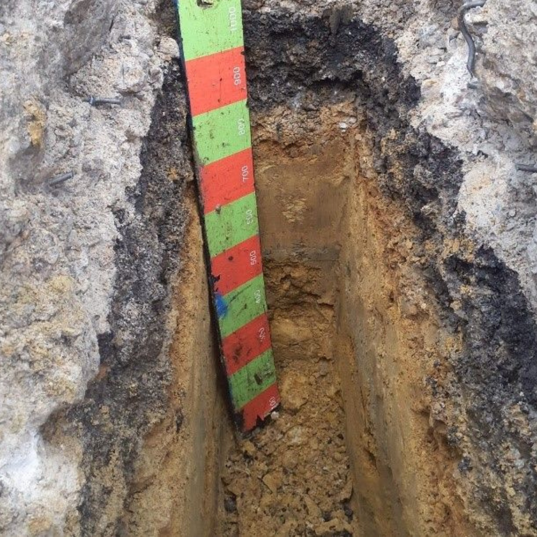
Pre-work investigations
Ever wondered what’s below the road surface?
We recently excavated several trial holes to help us determine the ground conditions and monitor for other utilities which may be in the area. This helps us to establish the best methods for laying the new pipeline and pinpoint the exact route it should take.
This photograph was taken at one of our trial holes. You can see that the ground make up shows the top tarmac layer of the road and reinforced concrete underneath, which is the main road structure and 300mm thick. You can see the changing geology from a hard, dark stone (600mm thick) to a sandy clay layer at the bottom of the pit. This shows the changing ground strata in the area and how it changes from a hard material, which is more difficult to break through, to a more easily dug area of clay.

Share this Article: